Flood Control
Dallas Levees & Pump Stations Overview
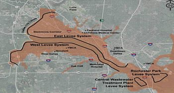
Quick facts about the Dallas Levee System:

- The overall levee system begins along the Elm Fork and West Fork of the Trinity River and continues through downtown Dallas. This system is referred to as the Dallas Floodway.
- The Levee System begins again along the southern Trinity River corridor with the Rochester Levee and the Central Wastewater Treatment Plant levees located in what is called the Dallas Floodway Extension Project area.
- In the Dallas Floodway, twenty-three miles of levees average a height of between 29' to 32'.
- The East and West Levee Systems were originally completed in 1932 and upgraded by the U.S. Army Corps of Engineers in 1960.
- In the 1990s, the City of Dallas built the Rochester Levee and upgraded the Central Wastewater Treatment Plant Levee.
- The Dallas Floodway Levee System includes sumps and drainage systems for 51 square miles of watershed protected by the levees.
- Six pump stations move floodwaters from the sumps behind the Dallas Floodway levees to the Trinity River, while an additional pump station serves the Rochester Levee. A seventh pump station is planned for the future.